Balloch Circuit, Loch Lomond and the Trossachs

P1060167P1000911

Total distance – 6.5 kilometres

Ascent – 120 metres

Walking conditions – Mainly tarmac paths. Gravel/soil footpath adjacent to Loch Lomond can be muddy or even submerged during particularly wet weather. Otherwise accessible by buggy.

Time required – Around 2 to 3.5 hours

Balloch is one of our favourite places. It’s a small yet bustling town sitting in one of Scotland’s most picturesque landscapes. There’s loads for the children to do so it’s always a popular choice of destination.

Park at Loch Lomond Shores Shopping Centre. The only down-side about parking here is that you might end up abandoning your walk and instead go shopping, visit Sea Life (watch out for two-for-one offers otherwise it’s quite expensive), or go for a coffee and soft play at the Tourist Information Centre. You can even visit the Maid Of The Loch paddle steamer.

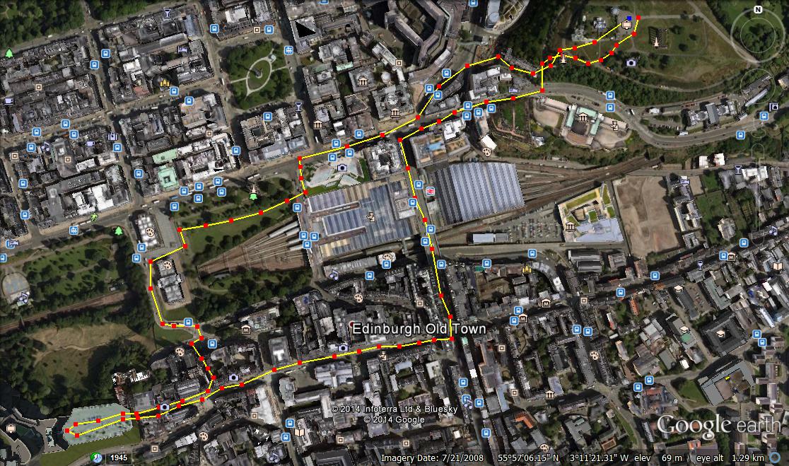
The route really starts just beyond Sea Life. Take the path going North East. After about 200 metres you cross a road and  the path bends off to the right and follows the River Leven for a few hundred metres. You then cross the road bridge and turn left to take the path at the river’s edge. From then on in it’s basically a big loop around Balloch Country Park. We usually do it in an anti-clockwise direction. This involves an easy ascent along tarmac paths past Balloch Castle (great spot for a picnic). The path then leads you down along the edge of Loch Lomond. Keep walking until you get to the road bridge you previously crossed. Return via the same route.

Balloch

Route

Pitlochry, Perthshire

P1020819

Total distance – 1.7 kilometres

Ascent –  60 metres

Walking conditions – Roads, pavements and good paths. Footpath through forest can be muddy. The stairs up Pitlochry Dam are a bit steep.

Time required – Around 45 minutes to 1.5 hours

My first impression of Pitlochry was that it is a picture postcard town set within a stunning Highland landscape. However, that didn’t explain why it was jam-packed with tourists and buzzing at all hours of the day. As it turns out one of the main reasons for this lies south of the River Tummel and is the Pitlochry Festival Theatre. But there are numerous other reasons for Pitlochry’s popularity. Recently, we did a little circular walk form the centre of town to the theatre taking in Loch Faskally by way of the Pitlochry Dam. This short and pleasant walk provided us with a good flavour of the place.

Park near the centre of town and make your way to the railway station which in itself is a place of interest. Take the path going east then turn right under the railway bridge. Walk past the car park, cross the road and take the footpath through the forest. This short forest walk takes you out at a small housing estate. To the left hand edge of this estate is a path that leads directly on to a footbridge taking you over the River Tummel. Turn right and you’ll pass by a very pleasant riverside pub with the theatre up the hill on the left. It’s a great place to stop for a picnic as there are plenty of wooden benches and a great view. Pitlochry dam is also a couple of hundred metres away. Walk along the road then make your way up a series or little stairways and channels which take you to the top of the dam. Cross the dam then make your way back to the railway station. There’s a quaint little footbridge you can cross between platforms.

We’ve been to Pitlochry on several occasions and each time stayed at Scotland’s Hotel which was great fun and relatively inexpensive. There are always new things to do and explore in Pitlochry and it won’t be long before we’re back.

Pitlochry

Route

Inchcailloch Island, Loch Lomond and the Trossachs

P1020221

P1020227

P1020210

Total distance – 2.8 kilometres

Ascent – 90 metres

Walking conditions – Good, well-defined footpath. Slightly steep ‘Summit Path’. No difficulties.

Time required – Around 1.5 to 3.5 hours

Nearest Town – Drymen

The first time we visited Inchailloch Island we were part of a large group on a guided tour with a Loch Lomond Park Ranger. Unfortunately, after about five minutes a boisterous, uncontrollable two year old who we all know and love prompted us to abandon the guided tour and instead wander around the island by ourselves. This turned out to be the perfect scenario as it enabled us to explore the whole island. And what an island it is!

Go to the Boat House at Balmaha (next to the Oak Tree Inn) and find out when the next boat to Inchcailloch leaves. They’re pretty regular (I think they run from around 0900-1700) and throughout the whole year. The ten minute boat trip takes you to the Inchcailloch North Jetty which you can see from the Boat House. When you get on the island simply follow the well-marked footpath (Central Path). This path leads directly to the beach/barbecue site of Port Bawn which is at the other side of the island. As you walk along this path you will see a marked path on your right leading off to the burial ground. Although not part of our route (see below) it’s a good diversion. You will also come across a well-marked path on the left (Summit Path) which takes you a circular route through the highest point on the island. This is a great walk through the trees and provides some of the best  views of Loch Lomond. Return to the main path and make your way to Port Bawn. On hot summer days expect large numbers of walkers and a party atmosphere. Return to the North Jetty via the Central Path and await pick-up.

When you get back to Balmaha you can let the children play in the play-park, feed the ducks, or walk along part of the West highland Way. Whatever you do take time to have a wander around this enchanted place called Balmaha.

Inchcailloch

Route

Glasgow Green to Buchanan Street, Glasgow

P1000707

Great Scottish Run/ Toddler Dash at George Square

Total distance – 5.2 kilometres

Ascent –  30 metres

Walking conditions – Entirely roads, pavements and good paths. No difficulties.

Time required – Approximately 2 hour’s walking time plus however long you wish spend at the numerous attractions

Glaswegians like a long lie at the weekend; apart from those who haven’t been to bed yet. This provides the fantastic opportunity of going for a morning walk around some of the Scotland’s busiest and most interesting streets whilst it’s still quiet.

Park at Templeton Street on Glasgow Green. Walk along this road and you will quickly reach the Doulton Fountain, which is the world’s largest Terracotta fountain and lies next to the People’s Palace. The People’s Palace is also a great tourist attraction. Apart from the museum (free entry) which charts the history of Glasgow there is a magnificent large glasshouse at the back which is home to a delightful café and features a variety of trees and shrubbery and leads out into beautiful gardens. From there, walk to the other side of Glasgow Green and cross the road at the High Court. Follow the path next to the Clyde for a few hundred metres then turn right just past the St. Enoch’s Centre. This will take you directly to the pedestrianized zone of Buchanan Street which my wife reliably informs me is one of Europe’s great retail centres. Walk as far as the Buchanan Galleries then walk down to George Square. There is always something going here including any manner of street performers and organised displays.

By now you will probably experience the dilemma of choosing somewhere to go for lunch. If you walk from George Square down Queen Street you will find a number of well-reputed places to eat at Royal Exchange Square. Then make your way back to Glasgow Green via Argyll Street.

There are some really good play-parks in Glasgow Green particularly the one on Templeton Street which should be close to where you’ve parked.

Glasgow Green

Route

Conic Hill, Balmaha, Loch Lomond and the Trossachs

100_2739

100_2738

P1020152

P1020160

P1020191

Total distance – 4.2 kilometres

Ascent – 360 metres

Walking conditions – Good well-defined footpath, slightly steep in places. No difficulties.

Time required – Around 2.5 to 4 hours

Nearest town – Drymen

Conic Hill sits directly on the Highland Boundary Fault Line and is a joy to behold. Conic Hill also bailed me out of a very tight spot once. It was around New Year and I had just invited my future wife out on our first date. The plan was to go ice skating in George Square, Glasgow. However, when we reached George Square to my horror the temporary ice rink was no longer there. Thinking quickly I suggested a trip to Balmaha and so it was agreed. As we sat in Balmaha having dinner in the Oak Tree Inn the allure of Conic Hill proved too much. Re-assuring my future wife that her Converse pumps were adequate for a walk up Conic Hill in fading light and icy conditions we set off. Unbelievably, it actually went well although I have to say that I do not condone this type of reckless behaviour, but that’s first dates for you. Then again, you could never go wrong with a trip to Conic Hill.

Start your walk from the large car park at the foot of Conic Hill and next to Balmaha’s Visitor Centre (the car park fills up quickly on bright summer days so get there before 11 am on these occasions). Follow the forest track as it winds its way through the trees remembering to take a left at the first junction. From thereon it is a fairly steady ascent through the trees for a few hundred metres until you reach a gate at the end of the forest. As you walk onto the open ground you immediately start to appreciate the splendour of your surroundings. The path continues to climb a little steeply in some places until you are on the shoulder of Conic Hill. From here on in it’s just a steady climb to the top. You have the choice of staying on the path or walking directly up the shoulder for a better view.   When you reach the top you will be see a trig point surrounded by a diverse range of people. Some will be wearing full Gortex waterproofs whilst others will be wearing Converse pumps. They’ll all be smiling and gazing out over Loch Lomond. Return via the same route.

When you get back down you can let the children play in the play-park, feed the ducks, or even go on a boat trip to Inchcailloch Island. Whatever you do take time to have a wander around this enchanted place called Balmaha.

Conic hill, Balmaha

Route

Carn Aosda, Glen Shee, Aberdeenshire

P1040371

P1040368

Total distance – 3.8 kilometres

Ascent – 275 metres

Walking conditions – Fairly easy walking on footpaths and tracks although the boulders can be a little awkward in places during the descent. No real difficulties

Time required – Around 2 to 3 hours

Nearest town – Braemar

As of 14th October 2014 we can proudly announce to the handful of people who currently read this blog that our five year old daughter has conquered Carn Aosda and she is therefore now a Munroist. Admittedly Carn Osada is certainly not the most prestigious of Munros and it’s a fairly easy 275 metre ascent. Indeed, she made light work of it, albeit off the back of the usual promises of Haribos and Chocolate Buttons awaiting her at the top. Confectionery wasn’t the only treat at the top of the hill. There was also a crystal clear, breath-taking view and this is something my daughter will soon realise is not a treat to be taken for granted on Scotland’s 3000+ feet hills.

Park at the Glen Shee Ski Centre on the A93. At this point you are already over 650 metres above sea level. From here, there’s a short, steep ascent that brings you up to the café. You will now see a number of tracks and paths. Do not head up the direct route to Carn Aosda (that’s the way down) but opt instead for the well-defined winding path that takes you to the lowest point of the shoulder coming down from the summit. When you turn onto the shoulder it actually becomes a very pleasant high level walk with great views and it’s not that hard to forget that you’re close to a series of ski runs. This gentle shoulder takes you onto the summit and a large cairn presents itself. To return, walk down the straight, bouldery path which takes you back to the car park, pretty much as the crow flies.

Carn Aosda

Route

Drimmie Woods, Blairgowrie, Perthshire

P1040406

p1040396

P1040398

Total distance – 7.4 kilometres

Ascent – 180 metres

Walking conditions – Easy walking on forest tracks and good footpaths. Some walking on a single track road. No difficulties.

Time required – Around 2.5 to 3.5 hours

Nearest town – Blairgowrie

Over the years I’ve passed through Blairgowrie on my way to either Glen Shee or the Cairngorms. On this occasion, for the first time Blairgowrie was the destination and about time too. Blairgowrie is a town with a lot going on. This is certainly the case in terms of walking routes. Whilst driving we noticed numerous public footpath signs. This prompted a visit to the Blairgowrie Tourist Information Office where we received the Drimmie Woods tip-off. What the very helpful assistant failed to mention however, was the weird wooden boards nailed to the trees or the sinister looking wooden spider’s web lying at the side of the forest track. Were we being set up in some ‘Wicker Man’ style occult ritual? Read on…….


There is a parking place just outside Drimmie Woods on Drimmie Road which is about 4 kilometres outside Blairgowrie. It is at this point you get a flavour of the fantastic viewpoints which await you should you survive the first 1.5 kilometre walk through the dark, spooky forest with all the Blair Witch style paraphernalia I mentioned earlier. When you exit the tree line within about 200 metres you will see a lochan on your left, after which the path goes in a circuit returning to this point. There will be some walking on a single track road so watch out for the occasional vehicle. When you get all the way around go back through the spooky forest. Run past the locals who by now, are wearing fancy dress and have brought with them a large wooden structure that looks highly flammable. Jump in your car and drive…..anywhere.

Drimmie Woods

Route


Cathkin Braes, Glasgow

P1030853

Commonwealth Games at Cathkin Braes

P1070058

P1070050

P1040270

Total distance – 4.2 kilometres

Ascent – 60 metres

Walking conditions – Easy walking on good footpaths. Fairly flat. No difficulties.

Time required – Around 1.5 to 2.5 hours

Nearest town – Glasgow/ East Kilbride

Cathkin Braes is undoubtedly the best location to view Glasgow from the south. It is now home to one of the UK’s best mountain biking trails and was the setting for the Commonwealth Games mountain bike competition. It is also proof that walkers and mountain-bikers can co-exist without conflict. The vast network of tracks and paths within Cathkin Braes ensures that even on a busy day we tend not to get in each other’s way. What’s ideal about Cathkin Braes for us is that it is within easy walking distance from our house and if the children are misbehaving we can speed-march them up the hill or the bad fox will catch them.

The start of this walk is from the large car park on Cathkin Road which is a few hundred metres up the hill from Carmunnock (Glasgow’s only village). Head west across the fairly flat, open ground. After about 800 metres this leads to a viewpoint at the edge of the tree line over-looking Carmunnock and you can see as far as Arran. Then change to a north easterly direction until you enter the forest. Take one of the many tracks going east. It’s probably best to stay near to the tree line that you entered from. After about a kilometre you should come into open ground. You’ll see a building with a huge mast. Beside it is a trig point (we love trig points). This is a fantastic place to stop for a picnic as you can see the whole of Glasgow, the Campsies, Ben Lomond and beyond. From there walk over to the stone circle feature which is clearly visible form the trig point. To get back to the car follow any of the paths through the trees which run parallel to Cathkin Road.

A visit to Carmunnock is to be recommended. We’ve had great days out there at the Carmunnock Highland Games and we’ve often stopped at Mitchell’s for dinner and to look at the fish tank.

Cathkin Braes

Route

Calton Hill to Edinburgh Castle, Edinburgh

P1000979

Calton Hill

Total distance – 3 kilometres

Ascent –  80 metres

Walking conditions – Entirely roads and pavements. Some stairways could prove awkward for buggies.

Time required – Approximately 1.5 hour’s walking time plus however long you wish spend at the numerous attractions

A trip to Edinburgh is always a good day out. We’ve had particularly good times in the city centre during the Edinburgh Festival and also the Christmas Market. On our most recent visit we did a 3 Km loop incorporating the fantastic viewpoints of Calton Hill and Edinburgh Castle with a number of attractions in between.

This particular route starts at the top of Calton Hill. Parking near here can be quite difficult so we tend to have these excursions on a Sunday when there’s less traffic and less parking restrictions. Calton Hill can be easily accessed from all directions and is an easy 40 metre ascent. The only issue might be that if you’re using a buggy you may have to carry it up flights of stairs. When you get on top you’ve got a 360 degree un-interrupted panoramic view and it’s magnificent. You can also marvel at Edinburgh’s finest architecture including the National Monument and the City Observatory. Exit Calton Hill and turn right on to Calton Road, then a left at New Street over the railway line. You then take a right at Canogate onto the Royal Mile which leads up to Edinburgh Castle. On returning from the castle go left which takes you down to the Mound and the home of the Scottish National Gallery. Finally make your way back via the Princes Street Gardens.

If you’re visiting in December my wife recommends you get a coffee and Bailey’s at the Christmas Market to warm your cockles.

Calton hill

Route

Boat of Garten to Aviemore, East Highlands

tr

Boat of Garten Railway Station

Total distance – 7.7 kilometres

Ascent – 50 metres

Walking conditions – Well maintained forest tracks. Fairly flat. No difficulties.

Time required – Around 2 to 3 hours for the walk

Nearest town – Aviemore

Normally, when we go for a walk we make our own way back to where we started. However, when you’ve got the chance to incorporate a trip in a steam train as your return journey it’s an opportunity too tempting to pass up. That’s right! Both Aviemore Station and Boat of Garten Station are lying on the recently re-established steam railway. Brilliant!  

You’ll need a map and a compass for this one as you are on forest tracks and it’s not difficult to get lost. Please pay attention to points on the map that you can identify whilst you are walking. That said, it is a fairly straight-forward, very enjoyable walk along well maintained and generally flat forest tracks with fantastic views of the Cairngorms in the background. You are more or less walking in a south-south-westerly direction for the full 7.7 kilometres of the journey from Boat of Garten until you reach Aviemore.  

Aviemore is a fantastic, bustling town with a great atmosphere. It’s one of our favourite places for a mini-break so we would strongly recommend taking some time to wander around To get back to Boat of Garten simply jump on the steam train and you’ll be there in about 15 minutes. What a great day out it is!

Boat of Garten

Route