Category Archives: West Highlands

Camusdarach Beach,Morar, Highland

P1080758

P1080766

P1080776

P1080791

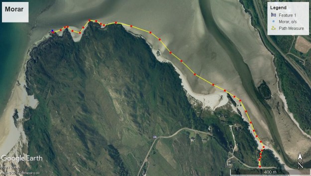
Total distance –  3.1 Kilometres

Ascent –  10 metres

Walking conditions – Sand and rock underfoot. No difficulties.

Nearest town – Mallaig

My wife was born and bred in a west of Scotland seaside town and is therefore an expert on the Gulf Stream. Being regular visitors of Largs my wife never misses the opportunity to inform me that the abundance of palm trees is a result of the Gulf Stream. I must confess that I am now losing the ability to display surprise and wonder at these revelations. Fortunately, our recent trip to Morar allowed my wife to enlighten me on a Gulf Stream fact that I am less familiar with. As it turns out the beautiful silver sand of Morar originates from the other side of the Atlantic and is transported by the Gulf Stream. And what a sight!

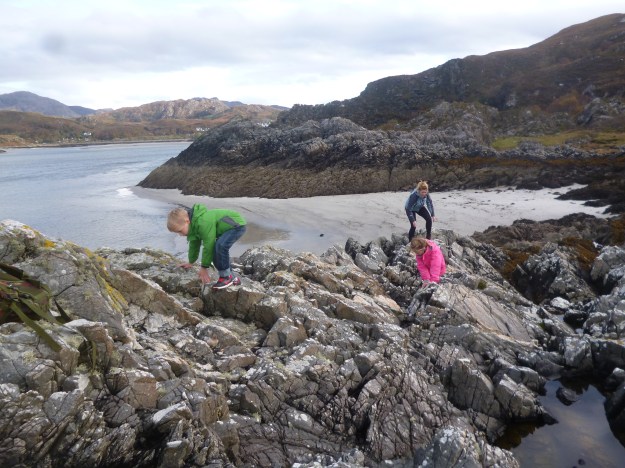
For this particular walk you don’t really need a route map as it’s basically a walk along one of the most breath-taking and magnificent beaches in Scotland. But for what it’s worth, we set off at the car park which is next to the public toilets on the B8008 a few hundred metres west of the A830 on the south bank of the estuary of the River Morar. From there, follow the short, sandy footpath straight to the beach. At this point, just turn left and walk across the sand in the direction of Muck, Rum and Eigg which you’ll see in the distance. Depending on the tide you’ll be able to walk for about 1 kilometre or so until the coastline bears left in a SW direction. At this stage you’re as well climbing a few feet onto one of the rocky outcrops for sandwiches and an uninterupted view of the islands. It’s then just a case of retracing your footsteps back to the car.

Make sure you visit the village of Morar whilst you’re there. If you’re lucky you might catch the Jacobite steam train at the station. And just next to the station across the level crossing, if you take the footpath to the left it takes you on a quick 30 metre ascent up to a fantastic viewpoint featuring a large cross.

Morar

Tarbet to Arrochar, Argyll and Bute


p1070041

p1070035

Total distance –  3.8 Kilometres

Ascent –  50 metres

Walking conditions – Well-defined footpaths. No difficulties.

Nearest town – Arrochar

Question: What can be better than walking a path linking Loch Lomond to Loch Long with clear views over-looking the area?

Answer: Realising when you reach Arrochar that some genius and visionary has recently opened a chippy and there are fish suppers galore!

The footpath to the chippy starts under the bridge at Tarbet Rail Station. The route couldn’t be any more straight forward. The path makes an initial short ascent then skirts along the side of Cruach Tairbeirt and parallel to the A83 for around 1.2 Kilometres. The path then bears right then takes you down to Arrochar and said chippy. Take your fish/sausage/black pudding supper to the edge of Loch Long and marvel at the Arrochar Alps. Then about turn and make your way back to Tarbet Rail Station.

arrochar


Drymen to Balmaha, via Conic Hill, Loch Lomond

p1060023

p1060024p1060036


Total distance –  11.9 Kilometres

Ascent –  390 metres

Walking conditions – Well-defined footpaths, tracks and pavements. No difficulties.

Time required – 3.5 to 5.5 hours

Nearest town – Drymen

It was summer 1993 and an attempt by me and two friends to complete the West Highland Way. At the end of Day 1, we set up camp in Balmaha (camping there was entirely legal in those days). At that point, I was unaware that my friends had decided that they’d had enough of the West Highland Way and were hatching a plan to abandon me in the very near future. On the morning of Day 3, they did exactly that and jumped on the boat over to Ardlui. I carried on regardless. Despite the betrayal, I remember the whole episode with a bemused fondness. Twenty or so years layer, I thought that I’d take my wife and kids on part of that route. Was I abandoned on this occasion? No chance! I had the car keys.

A bus is required for this outing to save you having to walk all the way back. Buses between Drymen and Balmaha operate every couple of hours during the daytime, and it’s entirely up to you whether you want to start the walk from either Drymen or Balmaha. Most people would agree that the more enjoyable way is starting from Drymen. But be careful, if you do start from Drymen you’ll need to be sure that the kids will have enough energy after walking about 8 Kilometres to ascend almost to the top of Conic Hill before dropping down to Balmaha.

From the bus stop in the centre of Drymen walk on the path beside the B858 going east for around a Kilometre before turning left on to the dirt footpath that is clearly signposted as part of the West Highland Way. Indeed, from here on as you’re on the West Highland Way, the whole route is clearly signposted. For the next few Kilometres or so you’ll be walking on dirt footpaths and forest tracks in mostly wooded wooded areas and then onto open ground. At the 8 Kilometre point you will come to a bridge over the Burn of Mar which is at the foot of Conic Hill. From here it’s pretty much an unrelenting 200 metre ascent to almost the top of Conic Hill. The path skirts to the right past the summit missing out the last 30 metre ascent. However, if you’ve still got the energy, getting to the top of Conic Hill is absolutely worth it. Keep on the path and head straight back down to the car park at Balmaha. Here you’ll find an excellent visitor centre and if you cross the road you can feed the ducks in Loch Lomond or nip into the Oak Tree Inn for refreshments.

balmaha


Neptune’s Staircase, Banavie, Lochaber

P1050158

p1050157

P1050230

P1050241

Total distance – 4.7 kilometres

Ascent – 30 metres

Walking conditions – Mainly tarmac footpath. Buggy compatible. No difficulties.

Time required – Around 1.5 to 2.5 hours.

Nearest town – Fort William

In a bid to impress my wife I splashed out on a two night’s dinner, bed and breakfast deal at the 4 star Moorings Hotel in Banavie, near Fort William. The amount of freebies on offer such as the range of biscuits in this 4-star paradise more than warranted the extra cost. But an added bonus was that the Moorings Hotel was right next to the Thomas Telford designed, Neptune’s Staircase. This engineering masterpiece just happens to be set in one of Scotland’s greatest landscapes, and can be taken in with a very enjoyable walk along the Caledonian Canal to Loch Linnhe.

Park in  the large public car park in Banavie, adject to the Moorings Hotel and walk a few metres to the Caledonian Canal, then turn right.Follow the canal across the road and over the level crossing followed by a 1.6 kilometre easy stroll along the banks of the canal until it meets Loch Linnhe. Cross over at the final sea-loch and you’ll find a delightful picnic area to stop to have your lunch at. The ducks will have already been pursuing you along the canal and are expecting to be fed, so make sure you’ve got some extra bread. Then it’s simply a case of walking back up the other side of the canal.  Keep going until you’ve got to the last footbridge, then turn left and walk back down to the car park. And don’t leave until you see a boat crossing the staircase because it’s a sight to behold.

Neptune's Staircase

Route

Signal Rock, Glencoe

P1050132

P1050129P1050124

p1050150

Total distance – 2.2 kilometres

Ascent – 80 metres

Walking conditions – Generally good footpath but can be muddy in places, particularly after heavy rain. No difficulties.

Time required – Around 1 to 1.5 hours.

Nearest town – Ballachulish

The Glen Coe Massacre was the scene of one of the most shameful and notorious nights in Scottish history. The torch that was lit by the Campbell’s to signal the start of the slaughter was positioned just to the rear where the Clachaig Inn now stands, so the story goes. The Clachaig Inn is also the location of a number of shameful, notorious but thoroughly entertaining nights. However, my most recent visit to the Clachaig Inn did not involve staggering in the pitch black back to the Red Squirrel campsite. Instead, it involved a short but enjoyable circuit around the Clachaig Inn, followed by a very reserved visit to the lounge, and then some time for the kids to play in the little park. Oh well!

Park close to the Clachaig Inn. (The Clachaig Inn is easily identifiable as there will be groups of people in the car park all wearing Gortex and pointing upwards towards the Aonach Eagach ridge). At the left hand edge of the car park follow the red gravel footpath. After about 400 metres you will reach the footbridge over the River Coe. This footbridge leads only to a car park next to the A82 and is not part of the route but its a fantastic spot and well worth stopping for. Anyway, the footpath goes to the right and ascends into the forest. Keep following the path for another few hundred metres and after a very short climb you will be at Signal Rock. Return via the same path for about 50 metres then take the footpath on the left. Although quite muddy in places this path will soon take you to a better track next to a small lochan on your left hand side then quickly leads you on to the road. Take a right when you get to the road and return to the Clachaig via the new ‘Orbital’ footpath which skirts this road. This is possibly, the best place to start and finish a walk that I can think of.

Signal Rock