Category Archives: Southern Scotland

Screel Hill, Palnackie, Dumfries and Galloway

p1060582


p1060574

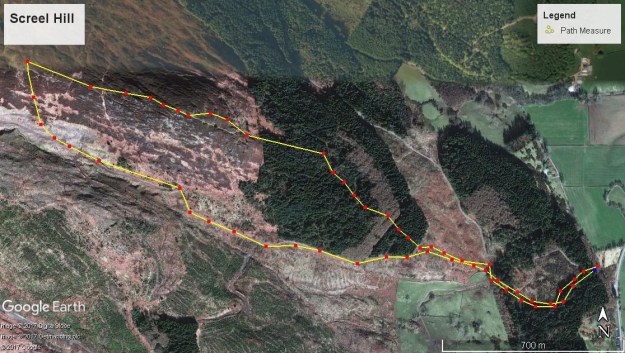
Total distance –  4.9 Kilometres

Ascent –   340 metres

Walking conditions – Well-defined footpaths and forest tracks. No difficulties.

Nearest town – Dalbeattie

Many walkers living within the Central Belt are instinctively drawn to heading north when they fancy a rugged ascent over rocky outcrops, having associated southern Scotland with rolling grassy hills. But that’s not the full story as anyone who has ascended Sceel Hill can attest to. Every one of its 344 metres is well-earned but also well rewarded.

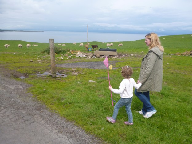
Set off from the Screel Wood forestry car park which is located about 4Km north of Auchencairn on the minor road just off the A711. You’ll walk up a winding forest track for a few hundred metres. As you emerge from the wood you’ll come to a track junction. Take the signed footpath directly in front of you through the trees and plants. After about 300 metres you’ll reach a bench next to a forest track. This is an ideal spot for a tea break. Cross over the track and keep following the footpath which eventually takes you to the crest of the hill. Continue 1Km along this undulating ridgeline with fantastic views of the Solway Firth until you reach a large cairn at the summit. The simplest way to return is by descending south to the footpath that takes you in a ESE direction and quite easily onto the forest track on the southern slope of the hill and back to the car park.

Screel Hill

Douglas Circuit, Lanarkshire

F

p1080069

p1080067

p1080076

Total distance –  6.2 Kilometres

Ascent –  200 metres

Walking conditions – Grassy and dirt footpaths which can be quite muddy in places. Some walking along single track roads (little or no traffic). No difficulties.

Time required – 2.5 to 3.5 hours

Nearest town – Lesmahagow

Make sure you’ve got a map and compass for this one, just in case you make a navigational error in the wooded area.

Douglas is home to the distinguished Cameronians Regiment, which after almost 300 years of service was disbanded in 1968. Renowned for their extremely fast marching pace, the Cameronians could have easily completed the 6.2 Kilometre Douglas Circuit in full kit within the hour. However, I’d have to say that in such beautiful, green, rolling landscape with a number of seats and picnic benches along the way, I’d recommend that you stroll around the route at a leisurely pace, eat your sandwiches at Castle Dangerous and enjoy the fresh air. Unfortunately for the Cameronians undertaking a forced march, the options of sandwiches and picnic benches would probably not have been available to them.

Driving into Douglas follow the parking signs and park at Douglas Valley Church. Start the route by walking past the church on the left hand side and then go down the stairs. Then walk over to St. Brides Church and a football field should come into view on the lower ground. You’ll see an opening onto the football field next to the tree line with a blue footbridge about 400 metres beyond, which is where you’re heading. The footpath is quite faint over this grassy field. Once you’re over the bridge the path is more distinct and heads up towards the forest on the high ground. When your in the wood keep to the footpath on the right. It soon turns into a wider forest track. After about 350 metres take the path veering right. The track then goes straight for about one Kilometre then a sharp right takes you downhill, past Gardens House, over a bridge and on to Castle Dangerous. Keep walking  and you’ll see the Cameronians memorial as well as the Stable Lake on your right hand side as you make your way back to the car park.

douglas


Tinto Hill, South Lanarkshire

P1030369

OLYMPUS DIGITAL CAMERA

OLYMPUS DIGITAL CAMERA

Total distance – 7 kilometres

Ascent – 490 metres

Walking conditions – Good footpath with a generally gravel surface. No difficulties.

Time required – Around 3.5 to 5 hours

Nearest town – Biggar

Tinto is Lanarkshire’s tallest hill standing at a height of 707 metres. It is one of the most popular and well-loved hills in Scotland. Tinto was also earmarked as our 5 year-old daughter’s first reasonably sized hill that she would walk all the way up to the top of by herself. ie not carried by me at any point. This is not as cruel as it might seem. The start point is at a height of over 200 metres so it’s not as onerous as it sounds. As yet, we do not have similar expectations for our three year-old son. He’s not fit enough yet and has too much common sense to be coerced into such thirsty work. Anyway, to cut a long story short, our daughter triumphed and we are very proud.

After parking in the car park at the foot of the hill we set off on our 490 metre ascent and 3.5 Km long walk. The footpath is made up of gravel and sharp boulders with a couple of muddy bits thrown in, so boots are a must. The ascent is fairly gradual and you won’t be short of having features to identify and people to talk to as you make your way up on a clear day. You should reach the top within a couple of hours where you will be greeted by a trig point on top of a huge collection of boulders. Have a picnic and return by the same route. There are other possible descent routes but I stopped using them after the second time I got chased by a herd of cows. I have no idea why I didn’t learn my lesson after the first time. These cows have a bad attitude!

Tinto Hill

Route

Mull of Galloway, Dumfries and Galloway

P1030307P1030292

P1030333

Total distance – 3 kilometres

Ascent – 30 metres

Walking conditions – Flat, grassy terrain and single track road. Several faint footpaths. 

Time required – Around 1 to 1.5 hours

Nearest town – Stranraer/Portpatrick

Driving South from Portpatrick you will eventually get to Drummond. This place is well worth a visit but don’t make this the end of your journey. Take the single track road to Scotland’s most southerly point.

The Mull of Galloway website describes the lighthouse as one of the UK’s best kept secrets. However, judging by the number of visitors we saw someone has blabbed. And a good thing too!

The lighthouse itself is 115 steps to a glorious view of the Isle of Man, England, Ireland and some of the best of the Scottish coastline. The Gallie Craig coffee House is less than 100 metres from the lighthouse so you can then relax with tea and scones or perhaps a steak pie if you think you deserve it. This café is also a shop, has excellent toilets and is perched precariously on a cliff edge,

Why not go for a pleasant walk along the single track road to meet the cows and watch them have fun stopping the traffic. There are also a number of footpaths for easy walking. Just be careful if you are walking with young children as some of the footpaths are only a few feet away from the sheer cliffs.

The cottages beside the lighthouse which were originally used as quarters for the lighthouse workers are now available as holiday lets. We haven’t stayed there yet but it certainly seems like a good idea, although I must confess I might find it a little spooky!

Mull of Galloway

Route

Parton Walk, Loch Ken, Dumfries and Galloway

P1010371

P1010373

P1010364

Total distance – 2 kilometres

Ascent – 40 metres

Walking conditions – Good footpath up very gentle grassy slope

Time required – 1 to 1.5 hours

Nearest town – Castle Douglas

Loch Ken is one of the nicest parts of Kirkcudbrightshire and home to the Galloway Kite Trail. There are lots of walks and other outdoor pursuits to be had along the way. Whilst driving along Loch Ken we pulled into a layby at the Loch Ken Holiday Park (about halfway along Loch Ken on the eastern shore) to look at our map. It was then that we spotted the sign for the Parton Walk footpath.

Without a moment’s hesitation we got out of the car, crossed the road and joined the footpath. After a 1 Km walk and with only 40 m of ascent on this cold, bright and beautiful day, we made it to the fantastic viewpoint just in time for elevenses. Nowadays, elevenses is an underused term which we are trying our best to resurrect for no other reason than it provides us with another opportunity to eat biscuits during the day.

Parton Walk

Route