Tag Archives: west highland way

Drymen to Balmaha, via Conic Hill, Loch Lomond

p1060023

p1060024p1060036


Total distance –  11.9 Kilometres

Ascent –  390 metres

Walking conditions – Well-defined footpaths, tracks and pavements. No difficulties.

Time required – 3.5 to 5.5 hours

Nearest town – Drymen

It was summer 1993 and an attempt by me and two friends to complete the West Highland Way. At the end of Day 1, we set up camp in Balmaha (camping there was entirely legal in those days). At that point, I was unaware that my friends had decided that they’d had enough of the West Highland Way and were hatching a plan to abandon me in the very near future. On the morning of Day 3, they did exactly that and jumped on the boat over to Ardlui. I carried on regardless. Despite the betrayal, I remember the whole episode with a bemused fondness. Twenty or so years layer, I thought that I’d take my wife and kids on part of that route. Was I abandoned on this occasion? No chance! I had the car keys.

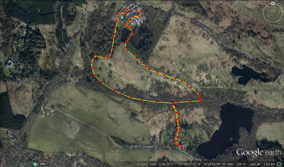
A bus is required for this outing to save you having to walk all the way back. Buses between Drymen and Balmaha operate every couple of hours during the daytime, and it’s entirely up to you whether you want to start the walk from either Drymen or Balmaha. Most people would agree that the more enjoyable way is starting from Drymen. But be careful, if you do start from Drymen you’ll need to be sure that the kids will have enough energy after walking about 8 Kilometres to ascend almost to the top of Conic Hill before dropping down to Balmaha.

From the bus stop in the centre of Drymen walk on the path beside the B858 going east for around a Kilometre before turning left on to the dirt footpath that is clearly signposted as part of the West Highland Way. Indeed, from here on as you’re on the West Highland Way, the whole route is clearly signposted. For the next few Kilometres or so you’ll be walking on dirt footpaths and forest tracks in mostly wooded wooded areas and then onto open ground. At the 8 Kilometre point you will come to a bridge over the Burn of Mar which is at the foot of Conic Hill. From here it’s pretty much an unrelenting 200 metre ascent to almost the top of Conic Hill. The path skirts to the right past the summit missing out the last 30 metre ascent. However, if you’ve still got the energy, getting to the top of Conic Hill is absolutely worth it. Keep on the path and head straight back down to the car park at Balmaha. Here you’ll find an excellent visitor centre and if you cross the road you can feed the ducks in Loch Lomond or nip into the Oak Tree Inn for refreshments.

balmaha


Mugdock Country Park, Milngavie, East Dunbartonshire

P1040880

P1040888

P1020576

Total distance – 2.9 kilometres

Ascent – 60 metres

Walking conditions – Footpaths and tracks. Can be a little muddy after heavy rainfall. Buggy compatible on dry days. No difficulties.

Time required – Around 1 to 2 hours

Nearest Town – Milngavie

Milngavie is probably best known for being the town that always has its name mis-pronounced. But it’s also famous for being the start of the West Highland Way which is far more exciting. And Mugdock Country Park is directly across the road from the start of the West Highland Way. It’s an expansive park with countless walking routes in addition to playparks, a castle, garden centre,  and second world war installations to name but a few things. A great day out!

For one of our favourite routes, park at the garden centre and make your way south past the courtyard and on to the gravel track. This southerly track quickly veers to the right and you will soon see a large ruin. The track then curves around to the left until you start to walk in an easterly direction. After about 300 metres keep your eyes out for the footpath leading off to the right (you’ll see the castle on the right so you can’t really go too far wrong). This path takes you out over marshy ground. Not to worry though, because you’ll be walking on wooden decking. And after no more than a couple of hundred metres you’re in Mugdock Castle.

To return, follow the footpath back to the track but this time turn right for a couple of hundred metres. Then take the footpath going left. This takes you on a nice loop back to the car park via the Walled Gardens. Visit the café and visitor centre, then let the kids run about the playplay. This should ensure that they’re suitably exhausted and you can guarantee yourself a good night’s sleep.

Mugdock

Route

Inchcailloch Island, Loch Lomond and the Trossachs

P1020221

P1020227

P1020210

Total distance – 2.8 kilometres

Ascent – 90 metres

Walking conditions – Good, well-defined footpath. Slightly steep ‘Summit Path’. No difficulties.

Time required – Around 1.5 to 3.5 hours

Nearest Town – Drymen

The first time we visited Inchailloch Island we were part of a large group on a guided tour with a Loch Lomond Park Ranger. Unfortunately, after about five minutes a boisterous, uncontrollable two year old who we all know and love prompted us to abandon the guided tour and instead wander around the island by ourselves. This turned out to be the perfect scenario as it enabled us to explore the whole island. And what an island it is!

Go to the Boat House at Balmaha (next to the Oak Tree Inn) and find out when the next boat to Inchcailloch leaves. They’re pretty regular (I think they run from around 0900-1700) and throughout the whole year. The ten minute boat trip takes you to the Inchcailloch North Jetty which you can see from the Boat House. When you get on the island simply follow the well-marked footpath (Central Path). This path leads directly to the beach/barbecue site of Port Bawn which is at the other side of the island. As you walk along this path you will see a marked path on your right leading off to the burial ground. Although not part of our route (see below) it’s a good diversion. You will also come across a well-marked path on the left (Summit Path) which takes you a circular route through the highest point on the island. This is a great walk through the trees and provides some of the best  views of Loch Lomond. Return to the main path and make your way to Port Bawn. On hot summer days expect large numbers of walkers and a party atmosphere. Return to the North Jetty via the Central Path and await pick-up.

When you get back to Balmaha you can let the children play in the play-park, feed the ducks, or walk along part of the West highland Way. Whatever you do take time to have a wander around this enchanted place called Balmaha.

Inchcailloch

Route

Conic Hill, Balmaha, Loch Lomond and the Trossachs

100_2739

100_2738

P1020152

P1020160

P1020191

Total distance – 4.2 kilometres

Ascent – 360 metres

Walking conditions – Good well-defined footpath, slightly steep in places. No difficulties.

Time required – Around 2.5 to 4 hours

Nearest town – Drymen

Conic Hill sits directly on the Highland Boundary Fault Line and is a joy to behold. Conic Hill also bailed me out of a very tight spot once. It was around New Year and I had just invited my future wife out on our first date. The plan was to go ice skating in George Square, Glasgow. However, when we reached George Square to my horror the temporary ice rink was no longer there. Thinking quickly I suggested a trip to Balmaha and so it was agreed. As we sat in Balmaha having dinner in the Oak Tree Inn the allure of Conic Hill proved too much. Re-assuring my future wife that her Converse pumps were adequate for a walk up Conic Hill in fading light and icy conditions we set off. Unbelievably, it actually went well although I have to say that I do not condone this type of reckless behaviour, but that’s first dates for you. Then again, you could never go wrong with a trip to Conic Hill.

Start your walk from the large car park at the foot of Conic Hill and next to Balmaha’s Visitor Centre (the car park fills up quickly on bright summer days so get there before 11 am on these occasions). Follow the forest track as it winds its way through the trees remembering to take a left at the first junction. From thereon it is a fairly steady ascent through the trees for a few hundred metres until you reach a gate at the end of the forest. As you walk onto the open ground you immediately start to appreciate the splendour of your surroundings. The path continues to climb a little steeply in some places until you are on the shoulder of Conic Hill. From here on in it’s just a steady climb to the top. You have the choice of staying on the path or walking directly up the shoulder for a better view.   When you reach the top you will be see a trig point surrounded by a diverse range of people. Some will be wearing full Gortex waterproofs whilst others will be wearing Converse pumps. They’ll all be smiling and gazing out over Loch Lomond. Return via the same route.

When you get back down you can let the children play in the play-park, feed the ducks, or even go on a boat trip to Inchcailloch Island. Whatever you do take time to have a wander around this enchanted place called Balmaha.

Conic hill, Balmaha

Route

The Drovers Inn to Doune Bothy, Loch Lomond

P1050705

p1050735

P1050720P1050689


Total distance – 12 kilometres

Ascent – 300 metres

Walking conditions – Good, well defined footpath. No difficulties

Time required – Around 3.5 to 5.5 hours

Nearest town – Crianlarich

When I was a teenager, I somehow managed to convince one of my friends to accompany me on the West Highland Way. With no tent and minimum equipment the plan was to get from Milngavie to Doune Bothy by the end of the first day. We didn’t make it. At around 11pm, whilst sliding and falling about in a pitch black, rain-sodden Rowardennan Forest we opted to huddle together and wait for daylight. When daylight finally came we found that we were no more than 300 metres from our objective of Doune Bothy. We dried ourselves off in Doune Bothy, went for a sleep, got the boat across to Ardlui, and then went home. In hindsight it was a predictably disastrous first attempt at the West Highland Way and I still smile when I think about it. Similarly the walk from Inverarnan to Doune Bothy also makes me smile. Not least because it gives me a good excuse to visit the Drover.  

Park at the Drover and walk north for approximately 400 metres, then turn right over the bridge. Turn right again and simply follow the West Highland Way footpath south for 5 Km until you reach Doune Bothy. Doune Bothy is easily recognisable as at any given time there is likely to be at least one weary but cheerful hiker with a large rucksack sitting down eating a bar of chocolate. Sample the ambience, then turn around and walk back. It’s as simple as that.  

There’s a really good viewpoint just before the footpath drops down to Ardleish on the way to Doune Bothy. We always stop there for a picnic and photos. Don’t eat too much because the portions at the Drover are huge. Please don’t be scared off by the bear at the door. Even the ghosts are friendly. The Drover is always well worth a visit.

The Drover to Doune Bothy

Route

The Devil’s Staircase, Glen Coe

P1020935

Total distance – 3.6 kilometres

Ascent – 250 metres

Walking conditions – Good footpath primarily with gravel and boulders underfoot. A relentless ascent but never gets steep enough to cause any difficulties

Time required – Around 2 to 3.5 hours

Nearest town – Ballachulish

Dangerous and exhausting are two things you might expect from a place in Glen Coe called The Devil’s Staircase. Surprisingly, The Devil’s Staircase is actually a safe and easy winding walk that offers some truly magnificent views over the West Highlands. It was named not by outdoor enthusiasts but by General Wade’s road building soldiers who were lugging materials up and down it all day. Evidently, they did not share our enthusiasm for this stretch of land.

The whole exercise is a straight-forward undertaking. It should take you well under one hour to reach the top of the Devil’s Staircase. Park at Altnafeadh on the A82, directly across from Buachaille Etive Mor. Take the West Highland Way footpath (travelling roughly NNW). You will find this path right next to the parking bay. Simply follow the footpath as it winds its way up the 250 metre ascent of The Devil’s Staircase. At the top of the Devil’s Staircase there is a bealach marked by two large cairns. This is an ideal picnic spot with a fantastic view of the Mamores. Take plenty of time to identify some of the best mountains in Scotland and at the same time cheer on the West Highland Way walkers, as to them, the Devil’s staircase was indeed aptly named by General Wade’s soldiers. Return by the same route.

Devil's Staircase

Route