South Queensferry, West Lothian

P1040996

p1040988

Total distance – 7.2 kilometres

Ascent – 40 metres

Walking conditions – Roads, footpaths (or sandy beach). No difficulties. Buggy compatible.

Time required – Around 2 to 3 hours

Nearest Town – South Queensferry

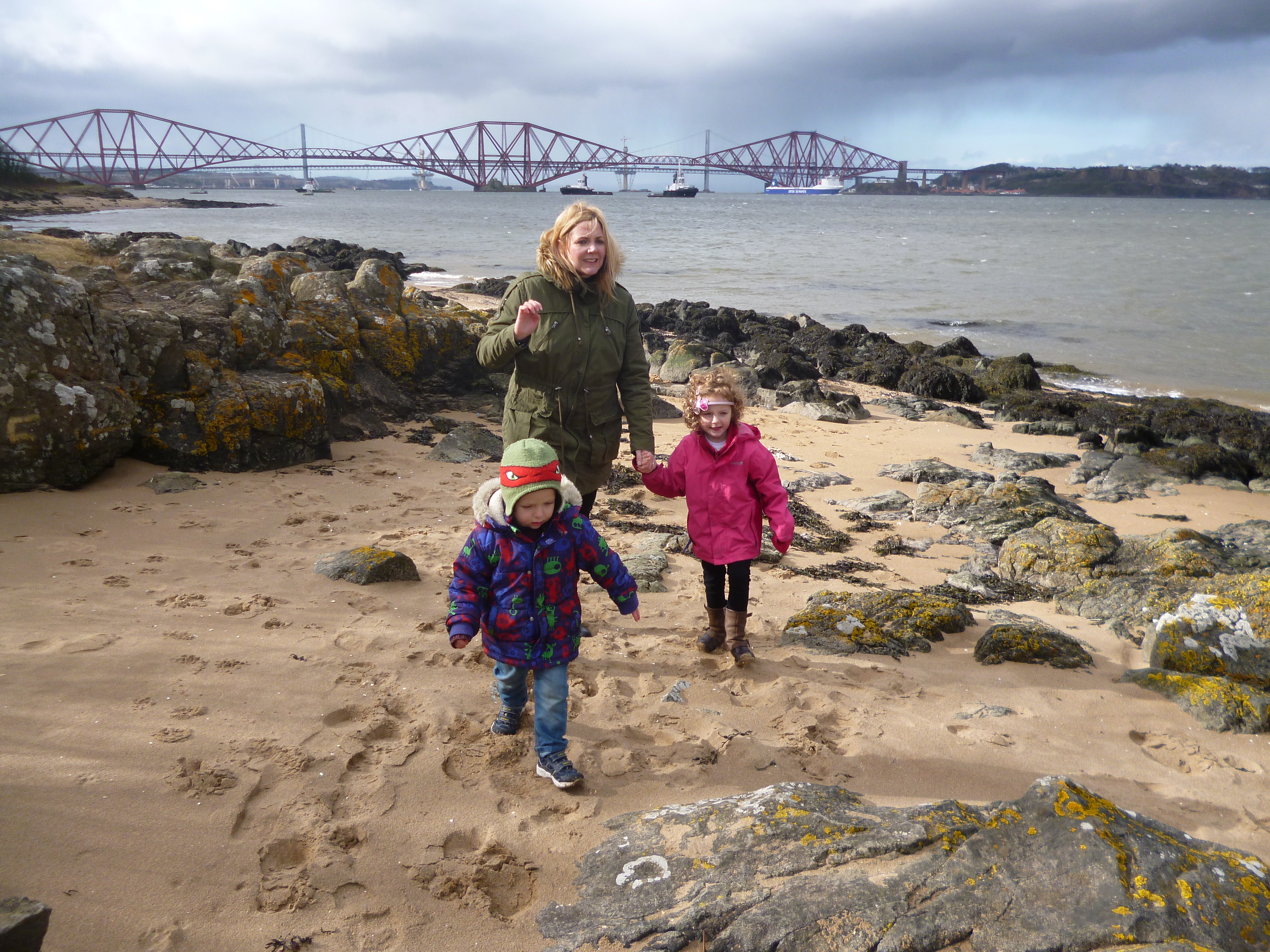
The South in South Queensferry may be optional, but a visit to this charming town on the shore of the Firth of Forth is obligatory. Try to visit before the new bridge has been constructed as the building works are amazing to look at. That’s right, there will soon be three bridges over the Forth, in close proximity. After all we’re in the land of plenty with trams and Holyrood and investment galore. The walks aren’t half bad either. The walk from South Queensferry to Hounds Point is just one such walk.

Find a parking space in the cobbled Queensferry High Street and follow this road going eastwards. After just over 1 Km you’ll be at the foot of the Forth Rail Bridge with Hawe’s Inn (featured in Robert Louis Stevenson’s Kidnapped) on your right. Another few hundred metres takes you to the start of the Dalmeny Estate. There’s no vehicles beyond this point so you’ll start to feel as if you’re now on a proper walk on a footpath. The path continues to skirt along the shoreline and before long you’ll be on the magnificent sandy beach of Hounds Point; a place that is well worth the walk in itself. Return via the same route.

South Queensferry

Route

Mugdock Country Park, Milngavie, East Dunbartonshire

P1040880

P1040888

P1020576

Total distance – 2.9 kilometres

Ascent – 60 metres

Walking conditions – Footpaths and tracks. Can be a little muddy after heavy rainfall. Buggy compatible on dry days. No difficulties.

Time required – Around 1 to 2 hours

Nearest Town – Milngavie

Milngavie is probably best known for being the town that always has its name mis-pronounced. But it’s also famous for being the start of the West Highland Way which is far more exciting. And Mugdock Country Park is directly across the road from the start of the West Highland Way. It’s an expansive park with countless walking routes in addition to playparks, a castle, garden centre,  and second world war installations to name but a few things. A great day out!

For one of our favourite routes, park at the garden centre and make your way south past the courtyard and on to the gravel track. This southerly track quickly veers to the right and you will soon see a large ruin. The track then curves around to the left until you start to walk in an easterly direction. After about 300 metres keep your eyes out for the footpath leading off to the right (you’ll see the castle on the right so you can’t really go too far wrong). This path takes you out over marshy ground. Not to worry though, because you’ll be walking on wooden decking. And after no more than a couple of hundred metres you’re in Mugdock Castle.

To return, follow the footpath back to the track but this time turn right for a couple of hundred metres. Then take the footpath going left. This takes you on a nice loop back to the car park via the Walled Gardens. Visit the café and visitor centre, then let the kids run about the playplay. This should ensure that they’re suitably exhausted and you can guarantee yourself a good night’s sleep.

Mugdock

Route

Falls of Clyde, South Lanarkshire

P1040863

p1040872

P1040856

Total distance – 4.8 kilometres

Ascent – 270 metres

Walking conditions – Footpaths and tracks. Can be muddy in many places especially after prolonged rainfall. Please be aware that there are some very steep drops which are close to the path in places. It can be very dangerous for children to veer off the path.

Time required – Around 2 to 3 hours

Nearest Town – Lanark

New Lanark World Heritage Site is the location of a large cotton mill once owned by Robert Owen. He was an early 19th Century celebrated philanthropist (his exploitation of poor people wasn’t as extreme as his peers) who has been credited with many social reforms including being the founder of infant childcare in Scotland. New Lanark Mill is a fantastic centre and apart from all the interesting and spectacular historical stuff, there’s loads to do with children. Attractions include a playpark, café, an old fashioned sweet shop, roof garden and the Annie McLeod Experience. Unsurprisingly, there are also a number of fantastic walks. In fact , there are no less than 5 official walks form this site alone. On any of these walks the one thing that needs to be stressed is that there will be places where the footpaths are perilously close to high vertical drops into the Clyde. So please keep young children beside you at all times.

From the heritage centre walk in a southerly direction along the footpath which skirts along the edge of the Clyde. After about 800 metres you’ll pass the hydro-electric station and a few hundred metres later you’ll see the falls at the Cora Linn. Continue your walk along the Clyde which in places is very close to sheer cliffs and soon you’ll pass the peregrine watch-site. After another few hundred metres you’ll then reach the falls at the Bonnington Linn where you can cross the Clyde if you so wish. Return via the same route.

Falls of Lanark

Route

Cort-ma Law, Campsies, East Dunbartontshire

OLYMPUS DIGITAL CAMERA

P1030828

P1030810

Total distance – 9.0 kilometres

Ascent – 440 metres

Walking conditions – Grassy footpaths with a steady, gentle gradient. Can be boggy in places. No difficulties.

Time required – Around 2.5 to 4 hours

Nearest Town – Lennoxtown

Cort-ma Law was one of the first hills we took the children up. It’s a very popular and busy hill. It’s also busy with sheep, as I’ve learned form past experience. Keeping dogs on the lead would be advisable, otherwise you might have to go up and down the hill twice in one day.

Start from the car park next to the shops at Clachan of Campsie (or if you prefer you can cut a bit off the walk by starting from the  large car park at the Crow Road just up the hill from Lennoxtown). Make your way along the clearly signposted path going northwards for about 500 metres until you reach the car park on the Crow Road. There’s often an ice cream van here during the summer so it’s a great morale booster. From there, cross the road then make your way up the broad grassy shoulder going east. The ascent of Cort-ma Law is fairly relentless but the gradient eases off as you reach the high ground which is more or less a plateau. You will immediately notice the fantastic views over the Clyde Valley and beyond, and now it’s just a matter of continuing along for a couple of kilometres until you reach the summit of Cort-ma Law.  The summit’s even got a trig point! It can however, be quite a long walk for the very young. As such, there have been times when we have turned back at one of the little high points marked with cairns along the way. Either way, it’s an excellent high level walk along the top of the Campsies. Return via the same route.

Cort-ma Law

Route

Chatelherault Country Park, South Lanarkshire


P1040731

p1010313

P1040307

P1030216

Total distance – 7.9 kilometres

Ascent – 280 metres

Walking conditions – Footpaths and tracks. Can be muddy in many places especially after prolonged rainfall. Please be aware that there are some very steep drops along the Avon Gorge which are close to the path in places. It can be quite dangerous for children to veer off the path.

Time required – Around 3 to 4.5 hours

Nearest Town – Hamilton

Chatelherault Country Park is an extremely popular destination for locals and far-travelled visitors alike. Most will head straight to the visitor centre which has been built onto the back of Chatelherault Hunting Lodge. The visitor centre hosts a 12 feet long tunnel featuring a badger and fox which flash when you crawl past them (this information is largely irrelevant unless you are under 7 years  old). The lodge itself was built in 1732 and undoubtedly remains one of Lanarkshire most prestigious buildings (my sister got her wedding photographs taken there) and is well worth taking some time to look around. There are also fantastic paths and nature trails which take in several interesting features. In particular, the ‘Green Bridge’ and ‘White Bridge’ circuits are excellent walks. Currently, the ‘White Bridge’ circuit can not be completed due to a landslide so we opted for the longer Green Bridge route.

From the car park head to the Visitor Centre. From the Visitor Centre (if going clockwise) take the footpath pointing to ‘White Bridge’ . This path follows the Avon gorge and steadily drops towards the river’s edge. The path then skirts along the river’s edge for about 800 metres until a wooden stairway takes you back up to the higher ground. The path then weaves its way along until it eventually drops down to the Green Bridge. After crossing the bridge you’ll find yourself on the other side of the Avon. Simply turn right and follow the path. This takes you back along the Avon gorge and through the fields, forest tracks, Cadzow Oaks, Cadzow Castle and then across the Duke’s Bridge to the Visitor Centre.

Chatelherault

Route

The Largs Hills, Inverclyde

P1040084

p1040063

Total distance – 3.7 kilometres

Ascent – 180 metres

Walking conditions – Footpaths, faint in places. Easy going over grassy expanse. No difficulties.

Time required – Around 1.5 to 2.5 hours

Nearest Town – Largs

It’s hard to go wrong on a day out to Largs. You can wander along the coastline, visit the amusements and funfair, or perhaps board the ferry to the Isle of Bute and go for a cycle around Millport. We like to do all of these but we also like to go for a walk in the hills over-looking the town. The great thing about the Largs Hills is that they make for a fantastic summer stroll amongst magnificent surroundings.


Park at the picnic spot near the Haylie Reservoir which is on the left hand side of the A700 just up the hill from Largs. You’re already at a height of 150 metres, the view is breath-taking and there are several picnic benches adjacent to the car park. From  there you’ve pretty much got a free reign to wander anywhere you like. The ground is undulating and features a number of little hillocks. We chose to go on a 180 metre ascent to Cockle Loch, but in truth on this bright and sunny day we could have picked just about any point on the landscape. There are a number of footpaths which tend to be quite faint but the going is easy and even walking on rough ground is not a problem.


Make sure you explain to the children why there are palm trees in Largs  because it’s always good to mention the Gulf Stream. And don’t forget to go to the chippy!

Largs Hills

Route


Strathclyde Loch and Mausoleum, Lanarkshire

P1040651

Christmas time at M & D’s

Total distance – 7.1 kilometres

Ascent – 50 metres

Walking conditions – Tarmac footpaths. No difficulties

Time required – Around 2 to 3.5 hours

Nearest Town – Hamilton/ Motherwell

Strathclyde Loch could never be described as a Mecca for hill-walking enthusiasts. However, it’s a good, healthy circular walk with an excellent view of Tinto Hill. It’s both buggy and pram-friendly. Indeed, it’s the place where I used to jog with the pram to accompany my wife when she took up running. Strathclyde Park is also home to M & D’s as well as a state of the art water sports centre which was used for the Commonwealth Games. There’s also play-parks at various points around the route. In a nutshell, there’s loads to do and most of the the population of Lanarkshire know this. So go early to avoid them because it can get really busy. Oh, and make sure you scare the children with ghost stories about the abandoned mining village of Bothwellhaugh, which can be found, still in tact at the bottom of Strathclyde Loch.

The route could not be simpler. Park close to M & D’s and make your way to the loch-side. Then walk around the loch (we prefer anti-clockwise) on the tarmac path which goes around the edge of the entire the loch. The one deviation we would suggest is a quick visit to the Mausoleum. To get there cross the footbridge over the River Clyde which you will find just to the rear of the water sports centre. From there walk through the M74 underpass and you’ll see the Mausoleum in all its splendour just ahead of you on the right hand side of the path. Then about-turn back to the loch-side to finish off the circuit.

Strathclyde Park

Route

Falls of Acharn, Kenmore, Perthshire

hermit

Total distance – 1.8 kilometres

Ascent – 140 metres

Walking conditions – Track well-defined footpaths.

Time required – Around 1 to 2hours 

Nearest Town – Aberfeldy

We sat in the wonderful Kenmore village square pondering whether to travel on the road north or the road south of Loch Tay. We were swayed by the prospect of visiting the Crannog on the south road. However, when we got to the Crannog there appeared to be building works so we drove on for a couple of miles to Acharn village. By sheer chance I had parked next to the sign for the public footpath leading to the Falls of Acharn. Why not go for a walk, we thought? There was a packet of crisps and a Fruit Shoot in it for the children so they were up for it. And what a good impulse decision it turned out to be. As well as the chance to visit the spectacular Acharn Falls we were treated to a great view of Loch Tay and a visit to the Hermit’s Cave.  

Park in the village of Acharn. It’s a tiny village so it won’t take you long to find the footpath sign on the main road pointing up the track to the Acharn Falls. From there, it’s just a steady ascent up the track for about 650 metres until you come to the Hermits Cave. Perched on the edge of a precipitous gorge this 18th Century folly is well worth a visit. It’s then a very short walk to the falls. If you’re crossing via the viewing platform please keep a hold of your children as, although a magnificent crossing point, a child could easily crawl through the side of the platform (You can avoid this by crossing slightly further up). To return to your car, make your way back down other side of the gorge, again, keeping a tight hold of small children as there are steep drops in places just a few feet from the footpath.

Falls of Acharn

Route

Queen’s Park, Glasgow

P1040576

Total distance – 3.2 kilometres

Ascent – 60 metres

Walking conditions – Nearly all tarmac paths. No difficulties. Buggy compatible.

Time required – Around 1 to 2 hours

If you thought that the abundance of squirrels was the only reason to visit Queen’s Park you couldn’t be more wrong. Apart from being in the ‘trendy’ part of Glasgow’s South Side, Queen’s Park has a number of attractions including a glasshouse featuring the Zen Garden, ponds, tropical fish, exotic birds and an excellent reptile house. There’s even a small soft play area for the under 5s. And it’s all free! There is also much to keep you occupied on your way around the park.

Make your start/ finish point the Queen’s Park Glasshouse. From the Glasshouse exit right. After a few metres take another right leading onto a dirt footpath that takes you along the rear of the Glasshouse. After about 400 metres you will come out at the Queen’s Park Flagpole which is the highest and best viewpoint in Glasgow City. When you make your way down form there you’re pretty much just circum-navigating the park. Try to ensure that you visit the play-parks, nature pond and rose gardens. And don’t forget to keep your eyes peeled for squirrels!

Queen's Park

Route

Calderglen Country Park, South Lanarkshire

P1020882

Total distance – 2.4 kilometres

Ascent – 110 metres

Walking conditions – Good, well-defined footpaths. Can be muddy by the river in wet weather. Some walking on tarmac roads within park.

Time required – Around 1.5 to 2.5 hours

Nearest Town – East Kilbride

Calderglen Country Park is a great place to take children. There’s the Children’s Zoo (avec meerkats), the Conservatory which is adjacent to ornamental gardens, an impressive playpark, and the Courtyard Coffee Shop. There’s also some great walks and nature trails. And just along the road there’s East Kilbride shopping centre. So it’s a varied and full day out.

Park in the Calderglen Country Park overflow car park which is on the road to the left just as you enter the from the A726 Strathaven Road. From there make your way onto the footpath and turn left. Keep following this path for about 400 metres then it turns right taking you down a small incline and then along the side of the Rotten Calder River which is a tributary of the River Clyde. Keep walking for another few hundred metres until you come to a footbridge over the Rotten Calder. Cross the bridge and continue in the same direction you were walking. After about another 400 metres you will see a footbridge going back over the Rotten Calder. Cross it but this time walk in the direction you have come from. This path continues to skirt along the Rotten Calder, gaining a few metres in height as you go. You will soon reach a sign pointing to the ‘Visitor Centre’. You can either ignore the sign and return to the path from where you came. Alternatively, you can take advantage of this welcome diversion as it takes you to the park attractions. Return via the tarmac road. Please watch out for cars (speed limit here is 5 mph so there shouldn’t be a problem, but it’s best to keep a tight reign on the children just in case).

Calderglen

Route