Monthly Archives: September 2014

Ben A’an, Loch Lomond and Trossachs

P1040192

p1040189

OLYMPUS DIGITAL CAMERA

OLYMPUS DIGITAL CAMERAMAN

Total distance – 3.8 kilometres

Ascent – 340 metres

Walking conditions – Well defined footpath, muddy in places. Some steep rocky sections where children may require some close supervision and assistance. 

Time required – Around 3 to 4 hours

 Nearest town – Aberfoyle

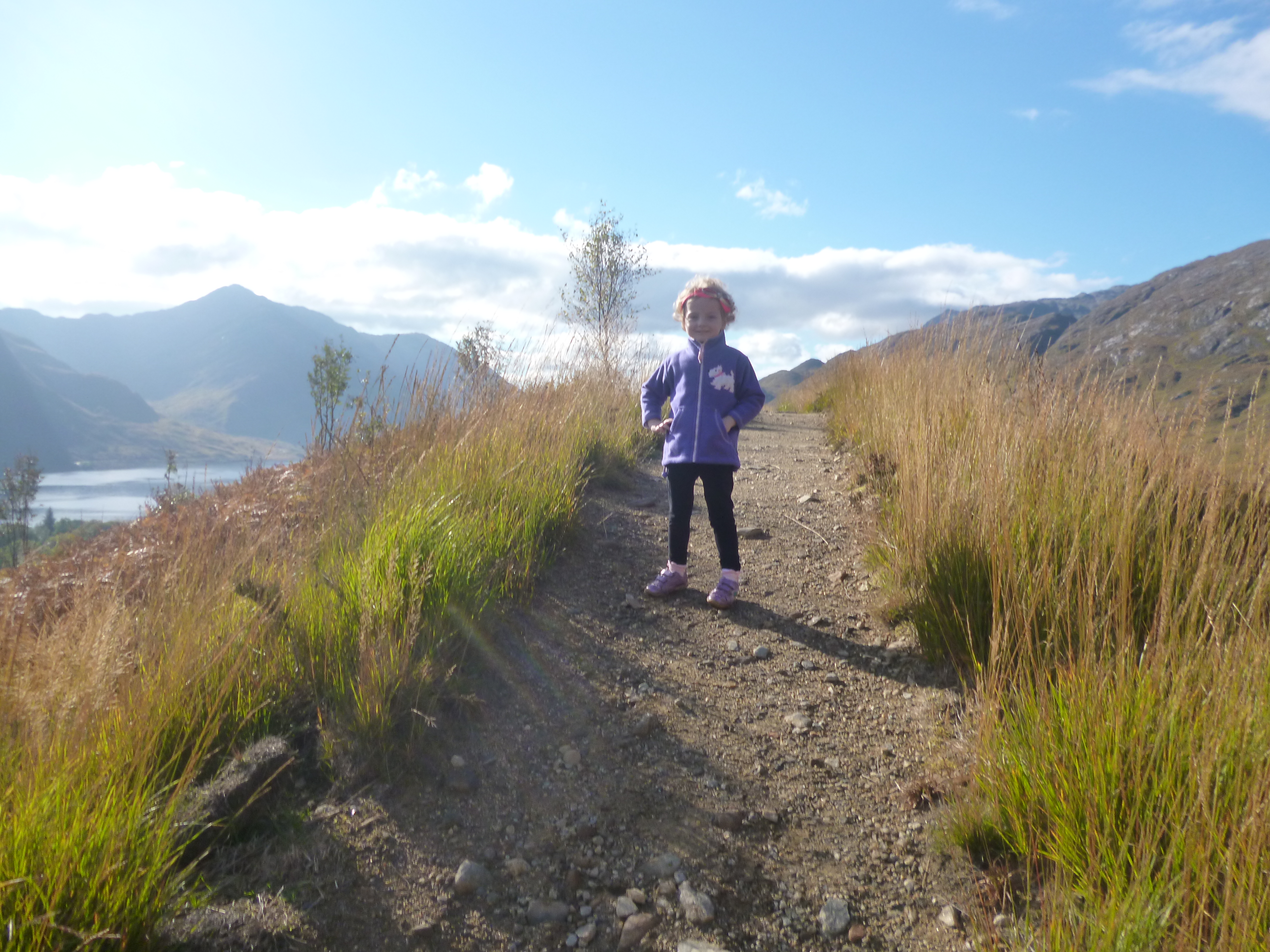
As a child living in Blantyre I learned that our drinking water came from Loch Katrine. I was entirely unaware that a boat named The Sir Walter Scott sailed on Loch Katrine on a daily basis. Equally, I had no idea that Ben A’an, a fantastic mini Alpine-esque hill sat beside Loch Katrine and that one day, a large photo canvas of my wife cuddling her little Lakeland Terrier on the top of Ben A’an with Loch Katrine in the background would take pride of place in my kitchen. Taking nothing away from my wife or her dog for that matter, but a photograph of Ben A’an and its surroundings on a clear day is a joy to behold.  

From the car park cross the road and follow the footpath as it winds its way up through the trees and over a little footbridge across a stream. After about 700 metres the ascent becomes a little gentler giving you the chance to stretch your legs on an easy stroll for a few hundred metres. It also provides the children with the opportunity to explore the numerous ‘dens’ and shelters constructed from upturned trees and branches and is the home of man-eating dragons, or so I told the children. The truth is probably far less exciting as I presume the ‘dens’ were built by youth groups participating in award schemes. Anyway, at about the 1.2 Km point there is a small clearing on level ground where you can see the top of Ben A’an and the final ascent which is fairly steep in places. Care should be taken as a trip in one of the steep sections could lead to a nasty injury, so please make sure you’ve got a firm hold of small children. Although steep, there are no difficulties and as you leave the trees you will be immediately overwhelmed by the magnificent scenery. It’s always a busy summit full of happy faces so bring a hearty picnic and a camera. Return via the same route.  

The Harbour Café at Loch Venachar which is located a couple of miles up the road towards Callander is a great spot to stop for lunch or dinner. It sits on Loch Venachar and you can get a table on the pier. My wife recommends the scallops with black pudding.

Ben Ann

Route

Glen Nevis Gorge Walk, Lochaber

P1030037

Total distance – 4.8 kilometres

Ascent – 40 metres

Walking conditions – Boots required. Some sections through the gorge require sure-footedness as they are a little awkward in places. Some precipitous drops close to footpath. 

Time required – 2.5 hours to Steall Ruins and back

Nearest town – Fort William

The first time I passed through the Nevis Gorge I was with a friend on route to Meanach Bothy. It was late at night, very dark and icy underfoot. Soon after negotiating this gorge we decided to stop and pitch a tent for the night. Unfortunately, it was my brand new tent and I hadn’t read the instructions on how to set it up. Embarrassingly, my friend and I, both tired and weary took the easy option of wrapping the tent around ourselves convinced we’d still get a good night’s sleep. We woke up in the early hours of the next day covered in snow. If I ever buy another tent I will not make this mistake again!

Driving along the single track road through Glen Nevis you will eventually reach an abrupt end to this road. That is where the footpath through the gorge begins. You will immediately be aware of the danger warning signs at the point of entering this path. Take heed of them but don’t necessarily be put off visiting the gorge. But please note: If you have small children, keep a tight hold of them as there are a few treacherous drops only a couple feet from the footpath. The rewards are great. After working your way through around 400 metres of a narrow gorge walk the landscape opens up into a magnificent gallery of mountains, waterfalls and a winding river. We normally walk through this wonderful setting for about a 1.5 Km to the Steall ruins next to the bridge. However, the last time we came here, we could not resist the lure of the Burma bridge across the river Nevis, not to mention the spectacular view of the Steall Falls for our picnic location. I’m not one to brag but I successfully negotiated the Burma Bridge because I like to show off in front of the children. On this occasion there were no serious consequences.

Glen Nevis Gorge

Route


Windy Hill, Muirshiel Counry Park, Renfrewshire

100_2005

P1010429

Total distance – 1.8 kilometres

Ascent – 60 metres

Walking conditions – Easy going, well-defined footpath

Time required – 2 hours

Nearest town – Lochwinnoch

Windy Hill is an ideal first ascent for toddlers, whether they want to or not. Does that sound wrong? It is little more than a pleasant stroll up a tiny hill. ie. 900 metres hike with 60 metres of ascent, but with great character and, wait for it……..a trig point!

Situated in Muirshiel Country Park, the footpath to Windy Hill starts next to the visitor centre. This in itself is a good place to keep the children busy and the toilets are clean and well maintained. The clearly sign-posted path weaves easily through a forest and then out onto about 400 metres of open ground leading to the foot of the final ascent. Before you know it you’ll be jubilantly placing your toddler on the summit trig point and promising that this will be the first of many bigger and better adventures. If your older children hear this, watch them shake their heads and roll their eyes. Too bad! Their fate is sealed. If it’s a nice day why not drive home the long way, stop off at Largs and celebrate this landmark achievement with an ice cream at Nardini’s. The Viking’s not too bad for a fish supper also.

Windy Hill

Route

Dumgoyne, Campsies, Stirlingshire

DSC_0274

P1070661

OLYMPUS DIGITAL CAMERA

Total distance – 4 kilometres

Ascent – 430 metres

Walking conditions – Good footpath up grassy slope. However, the slope is relentless and particularly steep in places. Children may require assistance descending the steepest sections.

Time required – Around 2.5 to 4 hours

Nearest town – Strathblane

This is the favourite hill of many a rambler, including my mum who is always guaranteed to point out Dumgoyne to anyone and everyone at any given opportunity. It wouldn’t be so bad but you can see it clearly from almost anywhere in her home town of Blantyre. Being part of the Campsie Fells, Dumgoyne sets itself apart and not just literally.


From the parking bay at Dumgoyne Distillery cross the road and follow the faint path over fields until you cross a stream beside a fence. At this point the route becomes a distinct footpath which leads directly up an increasingly steep slope straight to the top of Dumgoyne. The path is wide in places as a result of the large number of visitors who are probably avoiding the muddier parts of the path by going around the sides. Please try to avoid doing this as it causes considerable erosion. Although it’s hard work, before you know it you’ll be on the summit. Park yourself close to the trig point, get your sandwiches out, and strike up a conversation with whoever it is you will be sitting near to on this busy, extremely enjoyable and most sociable of hills.


Take care on the way down as it is particularly steep (although not dangerous) and should be avoided if there are not enough confident adults to ensure the children can get down without any dramas. Alternatively, take a leaf out of my wife’s book and slide down the steep slope on your backside. The children are guaranteed to do likewise.

Dumgoyne

Route

The Whangie, Kilpatrick Hills, East Dunbartonshire


P1010832

P1010838

P1010846

Total distance – 4.8 kilometres

Ascent – 180 metres

Walking conditions – Well defined footpath up a gentle slope but can be very muddy in places

Time required – Around 2.5 to 4 hours

Nearest town – Milngavie

High volumes of traffic pass by the apparently small and featureless Auchineden Hill on a daily basis. I, myself drove past on numerous occasions unaware of the hill’s hidden character. I did however think it strange that at this inconspicuous point on the A809 there was a large and invariably busy car park. I once stopped there for a cup of tea, looked at my map and noted a trig point at the top of Auchineden Hill and thought to myself that it’s probably a very nice viewpoint. Indeed it is, but that’s not the reason for this busy car park. In fact, what’s concealed from view and to the rear of Auchineden Hill is where according to folklore (I therefore can’t guarantee it is factually correct) the devil himself carved out a deep crevice in the hill with his tail. Locals later named this astonishing feature ‘The Whangie’. This cleft is long, very narrow, over 50 feet high in places and great to walk through. Inspired by this spectacle I ensured that my daughter would never in blissful ignorance pass by The Whangie so when she was seven weeks old we got her in the Baby Bjorn sling and took her there.


Take the footpath from the car park over the small dyke and follow this for around 300 metres. When you reach a fence, cross it and maintain the same direction which should mean that you are now skirting around the side of the hill in a westerly direction. Continue doing this for about 1.7 Km. It’s fairly easy going but can be muddy in places so boots are essential. Eventually you will reach the entrance to The Whangie. Stroll through this narrow cleft but beware that there are of a couple of fairly large drops. You could never fall off them doing normal walking but if a child was to start scrambling on the boulders there is scope for a bad accident.


When you reach the end of The Whangie there is a fantastic spot on the right hand side for a picnic. Or if you prefer, the footpath takes you 200 metres to the trig point. Take the direct route back down from the trig point to the car park. It’s easier walking and a lot less muddy.


If you’re driving back towards Glasgow I’d recommend that you reward yourselves with a hearty meal at the Carbeth Inn that is just a couple of miles down the road. You’ll recognise it by the large number of motorcycles parked outside. It is always very friendly, lively and the food is generous and of a good quality.

The Whangie

Route

Tinto Hill, South Lanarkshire

P1030369

OLYMPUS DIGITAL CAMERA

OLYMPUS DIGITAL CAMERA

Total distance – 7 kilometres

Ascent – 490 metres

Walking conditions – Good footpath with a generally gravel surface. No difficulties.

Time required – Around 3.5 to 5 hours

Nearest town – Biggar

Tinto is Lanarkshire’s tallest hill standing at a height of 707 metres. It is one of the most popular and well-loved hills in Scotland. Tinto was also earmarked as our 5 year-old daughter’s first reasonably sized hill that she would walk all the way up to the top of by herself. ie not carried by me at any point. This is not as cruel as it might seem. The start point is at a height of over 200 metres so it’s not as onerous as it sounds. As yet, we do not have similar expectations for our three year-old son. He’s not fit enough yet and has too much common sense to be coerced into such thirsty work. Anyway, to cut a long story short, our daughter triumphed and we are very proud.

After parking in the car park at the foot of the hill we set off on our 490 metre ascent and 3.5 Km long walk. The footpath is made up of gravel and sharp boulders with a couple of muddy bits thrown in, so boots are a must. The ascent is fairly gradual and you won’t be short of having features to identify and people to talk to as you make your way up on a clear day. You should reach the top within a couple of hours where you will be greeted by a trig point on top of a huge collection of boulders. Have a picnic and return by the same route. There are other possible descent routes but I stopped using them after the second time I got chased by a herd of cows. I have no idea why I didn’t learn my lesson after the first time. These cows have a bad attitude!

Tinto Hill

Route

Killiecrankie, Perthshire

P1020789

Total distance – 5 kilometres

Ascent – 140 metres

Walking conditions – Good footpaths and single-track road

Time required – Around 2 to 3.5 hours

Nearest town – Pitlochry

Over the past couple of years Pitlochry has become a favourite stomping ground of ours. It all started off with a two day dinner, bed and breakfast deal at Scotland’s Hotel, Pitlochry. We initially thought we had made a poor choice of hotel when the receptionist led us to our room which was in fact out of the hotel, across the road and into a converted house. We managed to keep our cool and a good thing too! This turned out to be one of the best places we’ve stayed in and we’ve been back a number of times since. We have found it impossible to get bored in Pitlochry. We will return again soon and perhaps, unlike last time, even conquer Ben Vrackie.

With the theatre just across the river from the centre of town, Pitlochry is always vibrant and there is a tangible party atmosphere about the place. We’ve not been to any wild parties yet but certainly have contributed to the general noise levels and commotion. We’ve also sought out things to do. A visit a couple of miles down the road to Killiecrankie was a particularly good day out and a very pleasant 5 Km walk. Park at the Killiecrankie Visitor Centre. Take the opportunity to have a walk around this tourist attraction. The staff are really nice and there are some fun things to do for the children. Then make your way to the clearly marked footpath which runs parallel to the River Garry and past The Soldier’s Leap. Keep following this path until you reach the road bridge over the River Garry. Then simply walk along the road as it gently ascends. After about 200 metres take the left fork in the road and after another 200 metres take a sharp left. This road provides an excellent vantage point at it gains about 100 metres in altitude along the way. After about 2 Km you will reach the car park next to the bridge. Do not cross the bridge. Instead follow the path beside the river leading north. After about 300 metres cross the footbridge over the River Garry. Then follow the path back to the Killiecrankie Visitor Centre.

Killiecrankie

Route

Glenfinnan Viaduct Circuit, Lochaber

P1020341

Total distance – 3.5 kilometres

Ascent – 130 metres

Walking conditions – Good footpath with no difficulties. Walking along side of road on return journey.

Time required – Around 2 to 3 hours

Nearest town – Fort William

Sometimes you know you’re lucky. This was one such occasion.  During the school October Week last year we stayed for a couple of nights at the Ballachulish Hotel. To our astonishment the weather on the second day was fantastic so we decided to head off to Glenfinnan.

After the usual stuff like visiting the Glenfinnan Monument and having a picnic at the edge of Loch Shiel, we decided to go for a walk. We noticed a track leading towards the viaduct which we duly followed. On reaching the viaduct to our very pleasant surprise, we discovered a newly constructed footpath leading up the hillside. Unable to resist we promptly set off up this footpath. After approximately a 90 metre ascent the path levelled out and skirted along the side of the hill for about 600 metres. This provided us with one of the most magnificent views we had ever witnessed. This statement should not surprise any Harry Potter fans. The footpath then led down to Glenfinnan Railway Station which is also a museum and is something of a must-see for anyone with a passing interest in steam trains. We then made our way back by following the road for 700 metres.

As we had a Dinner, Bed and Breakfast deal at our hotel,  unlike last time we didn’t go to the Glenfinnan House Hotel where I ate the best steak I’ve ever eaten nor did I then look out the window and see some deer bounding up and down the lawn in the most spectacular fashion. Maybe next time!

Glenfinnan

Route

Mull of Galloway, Dumfries and Galloway

P1030307P1030292

P1030333

Total distance – 3 kilometres

Ascent – 30 metres

Walking conditions – Flat, grassy terrain and single track road. Several faint footpaths. 

Time required – Around 1 to 1.5 hours

Nearest town – Stranraer/Portpatrick

Driving South from Portpatrick you will eventually get to Drummond. This place is well worth a visit but don’t make this the end of your journey. Take the single track road to Scotland’s most southerly point.

The Mull of Galloway website describes the lighthouse as one of the UK’s best kept secrets. However, judging by the number of visitors we saw someone has blabbed. And a good thing too!

The lighthouse itself is 115 steps to a glorious view of the Isle of Man, England, Ireland and some of the best of the Scottish coastline. The Gallie Craig coffee House is less than 100 metres from the lighthouse so you can then relax with tea and scones or perhaps a steak pie if you think you deserve it. This café is also a shop, has excellent toilets and is perched precariously on a cliff edge,

Why not go for a pleasant walk along the single track road to meet the cows and watch them have fun stopping the traffic. There are also a number of footpaths for easy walking. Just be careful if you are walking with young children as some of the footpaths are only a few feet away from the sheer cliffs.

The cottages beside the lighthouse which were originally used as quarters for the lighthouse workers are now available as holiday lets. We haven’t stayed there yet but it certainly seems like a good idea, although I must confess I might find it a little spooky!

Mull of Galloway

Route