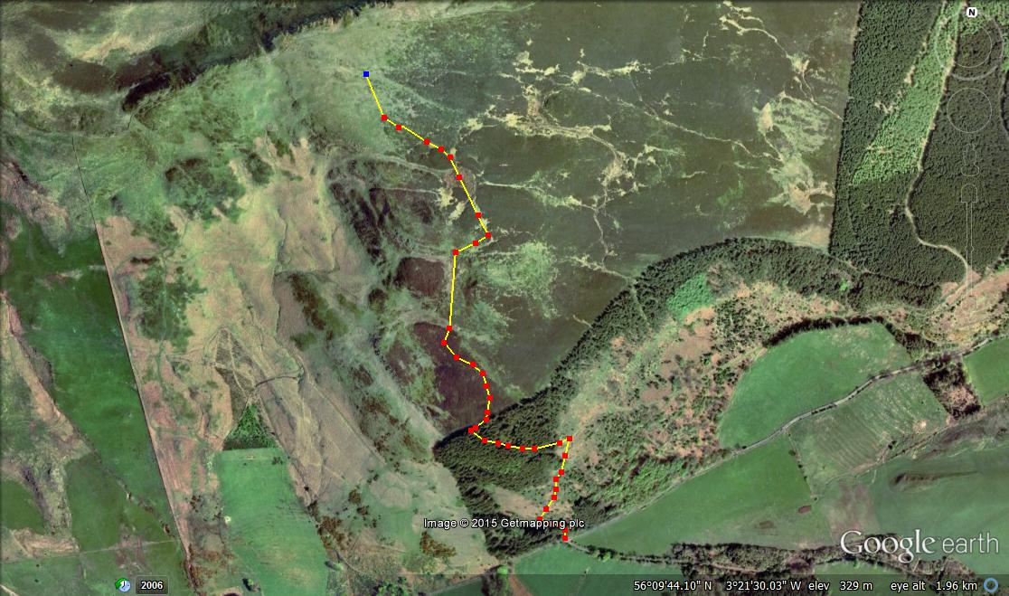
Author Archives: scotlandwalkswithchildren

Helensburgh to Rhu Circuit, Argyll and Bute

p1070220

Enter a caption

p1070239

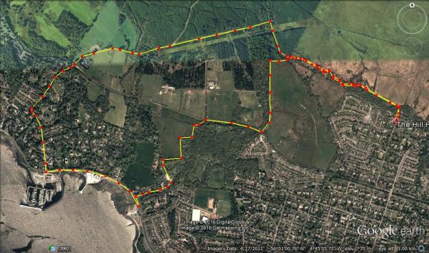
Total distance –  8.2 Kilometres

Ascent –  220 metres

Walking conditions – Well defined dirt footpaths and forest tracks. Some walking on pavements beside roads. No difficulties.

Time required – 2.5 to 4 hours

Nearest Town – Helensburgh

The fire at the Glasgow’s School of Art may well have destroyed some of Charles Rennie MacKintosh’s greatest work, but certainly not all of it. I’m reliably informed that Hill House is a shining example of the genius of Charles Rennie MacKintosh, but more importantly, it is the starting point of a delightful walk from Helensburgh to Rhu which provides fantastic views of the Firth of Clyde for most of the way.

Start at the footpath next to Hill House which is heading in a WNW direction. Continue on this path for about one Kilometre. Take the second footpath on the right (don’t take the first path that travels along the tree line up the hill or you’ll probably end up in Loch Lomond) for around 300 metres then go left. The path will now take you on a very gentle descent for about 1.5 Kilometres down to Rhu. This provides fantastic views of the Gare Loch and the Firth of Clyde. After you’ve wound your way through the residential area walk along the shoreline for about half a Kilometre when you’ll see a swing park and public toilets right next to the water. This is an ideal place to stop for a sandwich. It’s probably best to then double back about 100 metres into the residential area then ascend up through Duchess Wood to meet the footpath you started on, then make your way back across to Hill House.

Make sure you take the time to go for a wander around Helensburgh Town Centre. It’s got a large pier which is a fantastic spot to get tucked into a tasty Helensburgh fish supper!

helensburgh

Crail to Anstruther, Fife

p1050625 p1050601

Total distance –  6.5 Kilometres

Ascent –  50 metres

Walking conditions – Well defined dirt footpath. No difficulties.

Time required – Around 1.5 to 2.5 hours.

Everything’s an adventure when you’ve got small children. This exact thought occurred to me when I was jumping around excitedly on the top deck of the scheme bus from Anstruther to Crail trying to get a great family snap because it’s been a while since I’ve been on a bus. I then briefly re-considered my complete over-reaction to being on a bus, before taking another dozen photos.  Personally, I can’t think of a better plan than to jump on a bus only to walk all the way back to where you got on the bus. Especially if you’re at a particularly nice part of the Fife Coastal Path. Not to mention the bus stop being right next to an award-winning chippy, so the reward of a Fish Supper is on the cards.

From the bus stop in the centre of Crail, make your way towards the coast. You can’t miss it. We went down to the water right in the centre of town. however, the rocks and boulders were quite awkward to walk through so it’s probably best joining the coastal path at the Southern end of the town. The walk on the well-defined footpath is really straight forward and it’s just a case of following it back to Anstruther and you’re beside the sea the whole time. Highlights include some the very distinct rock formation that is known as ‘The Coves’. There is also a picture perfect play-park which is ideal for the kids just as you’re walking into Anstruther.

crail


Bracklinn Falls, Callander, Perthshire

p1070750p1070744


Total distance – 5.4 kilometres

Ascent – 170 metres

Walking conditions – Well defined dirt footpaths and forest tracks. some walking required along a single track road.

Time required – Around 2 to 3 hours.

Nearest town – Callander

Callander is a very busy town and for good reason. It’s a great place to visit with a nice little square next to the main road…..and a brilliant chippy. You can also feed the swans and ducks at the river Teith. Callander is also one of Scotland’s great outdoor centres, and as such there are a multitude of nearby walking routes for every range of ability. Bracklinn Falls is a stone’s throw from the town centre and is a great little circuit full of character.

Start from the well sign-posted Bracklinn Falls car park. Walk east for about 700 metres along the easy going footpath that winds down to the Keltie Water and to the spectacular Bracklinn Falls. Take photos, have a sandwich then cross the bridge and head in a generally northerly direction up a fairly steady gradient for about 1.5 Kilometers until the terraine starts to level off and you reach the end of the wooded area. You’re now on open ground above much of the surrounding area so the views are absolutely fantastic. If you’re really lucky, a couple of hundred metres ahead you’ll see a picnic bench and there’ll be nobody sitting there. It’s undoubtedly the best seat in the house! Continue along the track down to the bridge over the Keltie Water. Turn left onto the single track road which takes you directly back to the car park.

bracklinn-falls

The Antonine Wall, the Auchinstarry Circuit, North Lanarkshire

p1070769p1070783

P1060259

Total distance –10.2 kilometres

Ascent – 220 metres

Walking conditions – Well defined dirt footpath and tarmac cycle path. No difficulties.

Time required – Around 3.5 – 5 hours.

Nearest town – Kilsyth

What have the Romans ever done for us? If you’re a Monty Python fan you’ll know that there’s a long list of things that the Romans have done for us. What wasn’t mentioned in the Life of Brian however, were the numerous great walking routes for outdoor enthusiasts that the Romans built. The Auchinstarry Circuit is just one of them.

Start at the Auchinstarry car park which is just south of Kilsyth. Take a left from the car park and walk for about 200 metres and then turn left onto the Forth and Clyde canal path before the road crosses over the canal. Walk for about two Kilometres along the canal path. Cross the road bridge over the canal and follow the signed footpath up the slope of the hill. Veer right and that will take you up onto the higher ground. If you keep to the highest points along this broad ridge you’ll see signs of the wall together with tourist information. The path then drops down to the north end of Croy and then leads you across the road (the B802). Maintain the same westerly direction and after about one kilometre you’ll come to a very well preserved part of the Antonine Wall which then leads up to the top of Castle Hill. This provides a wonderful view of the surrounding area. The path then takes you on to Barhill Fort, down to Twechar, then a 2.5 Kilometre walk along the canal and straight back to the Auchinstarry car park.

The great thing about stopping at Auchinstarry is that when you’ve finished watching the rock-climbers on the quarry walls you can cross the road and go to the marina and visit the Boathouse for a good feed or some refreshments. The decked area is a fantastic spot and the wasps in attendance are friendly. Well, none of us got stung.

auchinstarry

Benarty Hill, Ballingry, Fife

P1050448

p1050459

P1050438

Total distance – 3.2 kilometres

Ascent – 170 metres

Walking conditions – Well defined dirt footpath. No difficulties.

Time required – Around 1.5 to 2.5 hours.

Nearest town – Glenrothes

I’ve always wanted to visit a kingdom and see knights joust for the hand of a fair maiden. Sadly, these kingdoms are long gone. Or are they? As it turns out, Fife is actually a kingdom so tell your squire to polish your spurs and saddle your horse, for this not-so -distant land is well worth a visit.

Within the Kingdom of Fife Benarty Hill lies just outside Ballingry. It has to be said that viewing it from the road is not something that is likely to excite you. However, Benarty Hill has got a fun little mountain path that allows a very quick ascent onto high ground that provides fantastic views of the whole of Fife and beyond.

Park in the small layby that is just over I Kilometre west of Ballingry. There’s a Benarty Hill footpath sign there  to confirm that you’re in the correct place. Make your way up the winding path through the trees. You’ll soon reach a bench at a path junction, This viewpoint is an ideal stopping point. Make sure you take the path on the left which will lead you out over a stile and onto the open hillside where the view to the South is now extensive. By continuing along the path for around 500 metres you will reach the first peak. And another 400 metres after that will take you to the summit featuring a trig point and a great view of Loch Leven to the North. Return via the same route.

Benarty Hill

Route

Neptune’s Staircase, Banavie, Lochaber

P1050158

p1050157

P1050230

P1050241

Total distance – 4.7 kilometres

Ascent – 30 metres

Walking conditions – Mainly tarmac footpath. Buggy compatible. No difficulties.

Time required – Around 1.5 to 2.5 hours.

Nearest town – Fort William

In a bid to impress my wife I splashed out on a two night’s dinner, bed and breakfast deal at the 4 star Moorings Hotel in Banavie, near Fort William. The amount of freebies on offer such as the range of biscuits in this 4-star paradise more than warranted the extra cost. But an added bonus was that the Moorings Hotel was right next to the Thomas Telford designed, Neptune’s Staircase. This engineering masterpiece just happens to be set in one of Scotland’s greatest landscapes, and can be taken in with a very enjoyable walk along the Caledonian Canal to Loch Linnhe.

Park in  the large public car park in Banavie, adject to the Moorings Hotel and walk a few metres to the Caledonian Canal, then turn right.Follow the canal across the road and over the level crossing followed by a 1.6 kilometre easy stroll along the banks of the canal until it meets Loch Linnhe. Cross over at the final sea-loch and you’ll find a delightful picnic area to stop to have your lunch at. The ducks will have already been pursuing you along the canal and are expecting to be fed, so make sure you’ve got some extra bread. Then it’s simply a case of walking back up the other side of the canal.  Keep going until you’ve got to the last footbridge, then turn left and walk back down to the car park. And don’t leave until you see a boat crossing the staircase because it’s a sight to behold.

Neptune's Staircase

Route

St. Andrew’s to the Rock and Spindle, Fife

P1050389

p1050418

P1050341

Total distance – 9.0 kilometres

Ascent – 90 metres

Walking conditions – Pavements, footpaths and tracks. No difficulties.

Time required – Around 2.5 to 4 hours.

St. Andrew’s is a magnet for royalty, the privileged and geology enthusiasts. That’s right, there are some fantastic rock formations along its coastline, so much so that even Prince William was lured to St. Andrew’s University to study. It makes for a fantastic walk even if your knowledge of geology is limited.

Try to get a parking space in or near the town centre (unfortunately many of the parking pay and display spaces have a two-hour maximum stay, so it’s probably best going fairly early in the morning). Make your way through the very distinctive arch over the road as you turn right at North Street with St. Andrew’s Cathedral on the left . This will lead you down to the harbour. It’s lovely here with fishing boats, a little ram-shackle, but quaint café, and a play park. It’s then just a matter of walking along the footpath which forms part of the 186 kilometre Fife Coastal Path.

The walk really gets going at the end of the tarmac path next to the caravan site. If you keep on walking you will soon see a 10 metre blade of rock next to the shore called ‘Maiden’s Rock’. It’s a great place to stop for a break and there’s a little dirt path leading down to it. Going back up to the main path you;ve then got the decision whether you want to take the lower path or the slightly higher path. Either way, they both skirt along the coastline and meet after a few hundred metres. Soon after that you’ll cross over a stile with the Fairmont Golf Course on the right. The path then drops right down to the shoreline . After 300m the coastline changes direction by around 90 degrees and within another few hundred metres you’ll see three large sea stacks. The Rock and Spindle is the largest and most spectacular of them. Have a picnic and a chat with any other visitors, but remember to either courtesy or exclaim ‘Viva la revolution!’, whichever you deem most suitable. If the person is sporting a beard and wearing a woolly jumper, just ask about fragmented basalt. Return via the same route but take time to go to the cathedral and wander about the town.

St. Andrew's

Route

Port nam Murrach, Arisaig

P1050194


p1050206

p1050198

Total distance – 4.6 kilometres

Ascent – 80 metres

Walking conditions – Mainly tarmac road and track. The stretch along the footpath can be quite muddy in places, particularly after heavy rain. No difficulties.

Time required – Around 2 to 3.5 hours.

Nearest town – Mallaig

Travelling on the A830 from Fort William to Mallaig is perhaps one of the most magnificent stretches of road in Scotland. Seven miles shy of Mallaig lies the picture postcard village of Arisaig. This is a place my wife has been raving about for years on account of a family holiday where she stayed there as a child. Nostalgia is not necessary for being blown away by the walk from Arisaig to Port na Murrach. Indeed, any moans or complaints about the walk being a little muddy in places, cease to be heard the minute you walk onto the beach.

From Arisaig, drive along the single track road signposted ‘Rhu’ to the parking spot at the end of the public road. From there walk along the private road/track for about 1.4 kilometres. At that point you will reach a private house with a sign pointing to the footpath on the left. This footpath leads past a hut and along a stone dyke. Due to the movement of livestock this can be particularly muddy. It only lasts for about one hundred metres then the going gets easier, although still muddy in places. Keep following this path until you drop down a rocky outcrop onto one of the most idyllic and picturesque beaches you are ever likely to see, with golden sand transported here from Mexico by the Gulf Stream. Make sure you have brought a map so you can identify all the islands and rock features which you see before you. Return via the same route. Oh, and if you go on a Sunday make sure you’ve got enough petrol because it’s a long way back to Fort William.

Arisaig

Route

Signal Rock, Glencoe

P1050132

P1050129P1050124

p1050150

Total distance – 2.2 kilometres

Ascent – 80 metres

Walking conditions – Generally good footpath but can be muddy in places, particularly after heavy rain. No difficulties.

Time required – Around 1 to 1.5 hours.

Nearest town – Ballachulish

The Glen Coe Massacre was the scene of one of the most shameful and notorious nights in Scottish history. The torch that was lit by the Campbell’s to signal the start of the slaughter was positioned just to the rear where the Clachaig Inn now stands, so the story goes. The Clachaig Inn is also the location of a number of shameful, notorious but thoroughly entertaining nights. However, my most recent visit to the Clachaig Inn did not involve staggering in the pitch black back to the Red Squirrel campsite. Instead, it involved a short but enjoyable circuit around the Clachaig Inn, followed by a very reserved visit to the lounge, and then some time for the kids to play in the little park. Oh well!

Park close to the Clachaig Inn. (The Clachaig Inn is easily identifiable as there will be groups of people in the car park all wearing Gortex and pointing upwards towards the Aonach Eagach ridge). At the left hand edge of the car park follow the red gravel footpath. After about 400 metres you will reach the footbridge over the River Coe. This footbridge leads only to a car park next to the A82 and is not part of the route but its a fantastic spot and well worth stopping for. Anyway, the footpath goes to the right and ascends into the forest. Keep following the path for another few hundred metres and after a very short climb you will be at Signal Rock. Return via the same path for about 50 metres then take the footpath on the left. Although quite muddy in places this path will soon take you to a better track next to a small lochan on your left hand side then quickly leads you on to the road. Take a right when you get to the road and return to the Clachaig via the new ‘Orbital’ footpath which skirts this road. This is possibly, the best place to start and finish a walk that I can think of.

Signal Rock


Rouken Glen Park, East Renfrewshire

P1020030

Total distance – 2.5 kilometres

Ascent – 50 metres

Walking conditions – Tarmac/dirt footpaths. No difficulties. Buggy compatible.

Time required – Around 1 to 2 hours

Nearest Town – Glasgow (South Side)

House prices in East Renfrewshire are notoriously high. Apparently, it’s all down to school catchment areas, but I wonder if Rouken Glen Park has something to do with it. Either way, Rouken Glen Park is still well worth a visit. There’s a brand new pirate themed play area in the middle of the park, so what further incentive do you need? What about an ice cream shop next to a boating pond? Oh, it’s got that as well.


Park in the large car park in front of the garden centre. The path to the left takes you to the wide open section of the park. You’ll immediately see the ‘pirate’ play area. By continuing along the path for a few hundred metres you’ll pass the skatepark on your left and then you’ll reach a small incline that leads to the boating pond. Walk around the pond clockwise, buy an ice cream then take a left. This will lead you to a spectacular waterfall down the White Cart. Cross the waterfall via a bridge, and then immediately take a right onto a delightful footpath which follows the stream and crosses a series of little bridges. This will lead you back to the wide open section of the park. Make your way back to the car park.

Rouken Glen

Route